|
|
Bow rest
by jaredhunts. 11/13/24 05:19 PM
|
|
|
|
|
|
|
|
|
|
|
|
|
|
1
|
2
|
|
3
|
4
|
5
|
6
|
7
|
8
|
9
|
|
10
|
11
|
12
|
13
|
14
|
15
|
16
|
|
17
|
18
|
19
|
20
|
21
|
22
|
23
|
|
24
|
25
|
26
|
27
|
28
|
29
|
30
|
|
|
118 registered members (Grokamole, Skillet, hunterturf, Bad06Z, Yellahammer, Sheepdog, Simpleman, Red Fox, Crappie, ronfromramer, Frankie, mopar, BCLC, GoldenEagle, Bronco 74, Sself161, TideWJO, Huntn2feed5, Treelimb, Chaser357, sj22, hallb, Thread Killer, IMISSALDEER, Uokman2014, dave260rem!, Bcleck90, Mack1, Joe4majors, salock, bamapanic, BamaFan64, T Bone, chuck216, Powers, Young20, BrentsFX4, HDS64, deadeye48, GomerPyle, Fishduck, WEMOhunter, buzzard, claybird, Bill H 280, ALPatriot15, jlbuc10, bamabeagler, RCHRR, oldforester, BPI, Hunting-231, Jotjackson, headshot, CeeHawk37, leroycnbucks, Woody1, Luxfisher, Gizmo76, Bandit635, Ridgehunter36, longshot, Morris, Buck2020, J_K, RebFormanUDA, G/H, CNC, BBD23, Backwater, BradB, dawgdr, cartervj, coosabuckhunter, Scott H, WALK#248, Tree Dweller, shootnmiss, Overland, jprice, donia, mossyback, Lvlhdd, klay, ParrotHead89, Swamp Dog, JKlep, BCD, rhino21, desertdog, CouchNapper, Willyb, fillmore, Stoney, AU coonhunter, 007, Big Game Hunter, Driveby, demp17, Keysbowman, mdf, Chaser1, Dixiepatriot, 7PTSPREAD, Ridge Life, JDW25, 12 invisible),
1,000
guests, and 0
spiders. |
|
Key:
Admin,
Global Mod,
Mod
|
|
|
 Rut Map
#1466359
09/30/15 06:25 AM
09/30/15 06:25 AM
|
Joined: Jan 2014
Posts: 6,733
Lake View, AL
Joe4majors
 OP
OP
14 point
|
 OP
OP
14 point
Joined: Jan 2014
Posts: 6,733
Lake View, AL
|
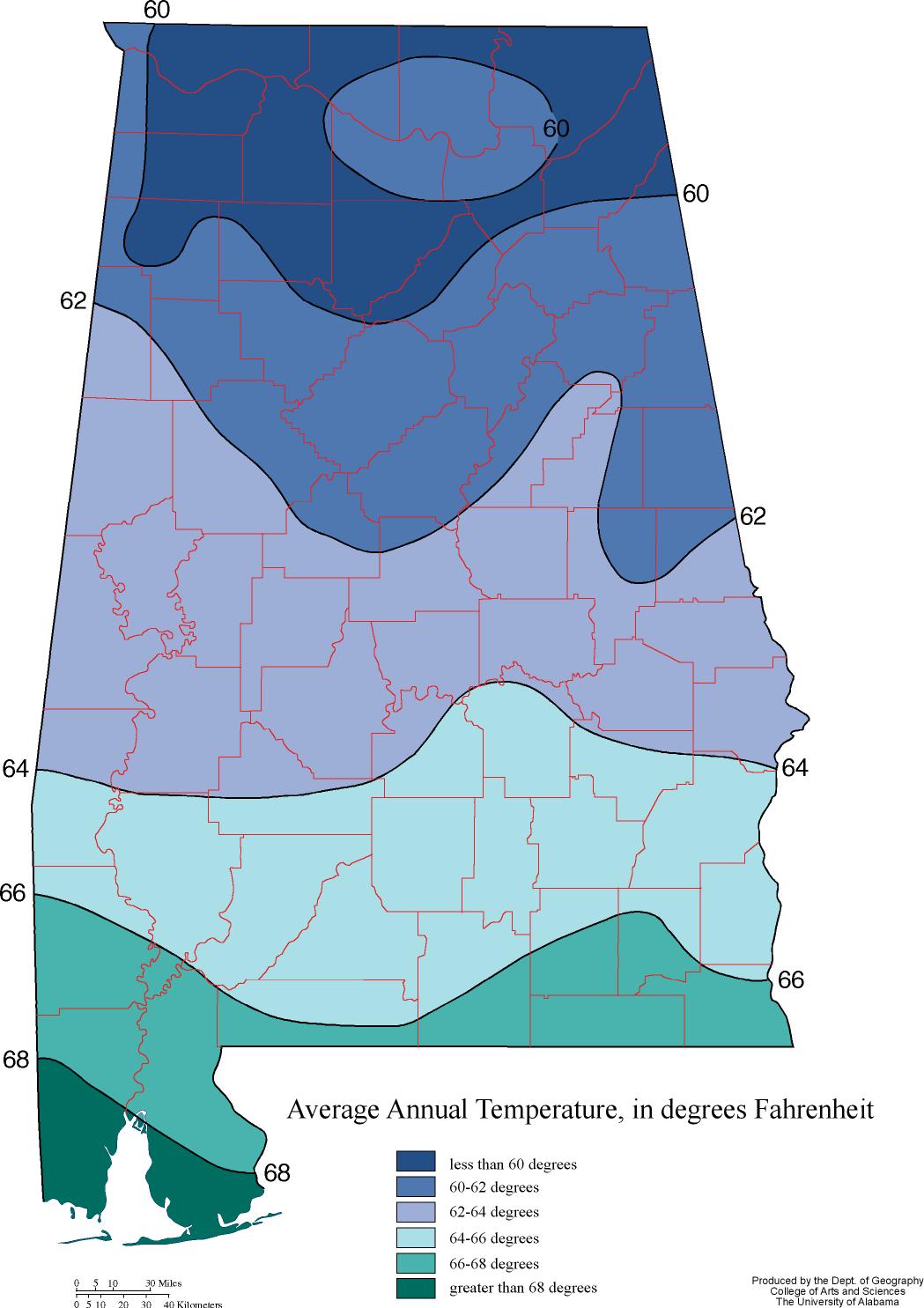
If we could somehow map up the dates of peak rut for deer in Alabama, do you think the map would have distinct zones, or be random pockets, or a hybrid of the two? I give the example map below of what I mean by zones, but I am not trying to relate this air temp map to rut so no need to comment on that. I don't know of a rut-timing map for the state (correct me if I'm wrong). Personally, I'm curious what patterns emerge, if any. For you mapping experts, do you think ALDEER could generate enough data to put a map together? 
|
|
|
 Re: Rut Map
[Re: Joe4majors]
#1466376
09/30/15 06:36 AM
09/30/15 06:36 AM
|
Joined: Dec 2002
Posts: 52,089
Round ‘bout there
Clem

Mildly Quirky
|

Mildly Quirky
Joined: Dec 2002
Posts: 52,089
Round ‘bout there
|
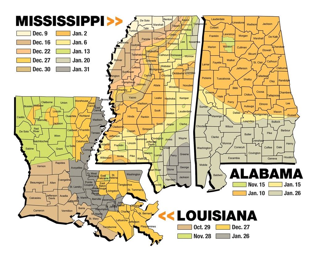
Georgia DNR has a rut map: http://www.georgiawildlife.com/rut-mapBlong, is that MS-LA map from one of their DNR's?
"Hunting Politics are stupid!" - Farm Hunter
"Bible says you shouldn't put sugar in your cornbread." Dustin, 2013
"Best I can figure 97.365% of the general public is a paint chip eating, mouth breathing, certified dumbass." BCLC, 2020
|
|
|
 Re: Rut Map
[Re: Joe4majors]
#1466382
09/30/15 06:38 AM
09/30/15 06:38 AM
|
Joined: Dec 2008
Posts: 834
Auburn, AL
Huntinman

6 point
|

6 point
Joined: Dec 2008
Posts: 834
Auburn, AL
|
What would you base the idea of 'rut' on? Black tarsal glands? Chasing? I would assume at least one of the rutting signs/signals/activities would have to be present to consider it a rut map in relation to the date the deer was killed or observed. I believe it can be done though. Accuracy would solely be based on participation rate and the 'rut' credentials in which the data and map would be based on.
GO NOLES!!
|
|
|
 Re: Rut Map
[Re: Joe4majors]
#1466393
09/30/15 06:45 AM
09/30/15 06:45 AM
|
Joined: Dec 2002
Posts: 52,089
Round ‘bout there
Clem

Mildly Quirky
|

Mildly Quirky
Joined: Dec 2002
Posts: 52,089
Round ‘bout there
|
I think what he means is "peak rut" with top activity, chasing, breeding, etc., that hunters look for as the prime time, since the "rut" is basically from the time the velvet comes off until the antlers drop.
"Hunting Politics are stupid!" - Farm Hunter
"Bible says you shouldn't put sugar in your cornbread." Dustin, 2013
"Best I can figure 97.365% of the general public is a paint chip eating, mouth breathing, certified dumbass." BCLC, 2020
|
|
|
 Re: Rut Map
[Re: Clem]
#1466408
09/30/15 06:50 AM
09/30/15 06:50 AM
|
Joined: Jan 2014
Posts: 6,733
Lake View, AL
Joe4majors
 OP
OP
14 point
|
 OP
OP
14 point
Joined: Jan 2014
Posts: 6,733
Lake View, AL
|
I think what he means is "peak rut" with top activity, chasing, breeding, etc., that hunters look for as the prime time, since the "rut" is basically from the time the velvet comes off until the antlers drop.
Yes, I just mean when the hunting gets good and the bucks let does get them killed. Obviously it is a time span rather than a single day, but thought it might be easier to map if specific as possible.
|
|
|
 Re: Rut Map
[Re: Blong]
#1466464
09/30/15 07:24 AM
09/30/15 07:24 AM
|
Joined: Jul 2011
Posts: 36,498
Boxes Cove
2Dogs

Freak of Nature
|

Freak of Nature
Joined: Jul 2011
Posts: 36,498
Boxes Cove
|
Not sure about bama but it is pretty close on the areas I hunt in Mississippi.  I'm real sure about Bama, not even close. And to the OP's question, it would be a patch work in much of the state. Someone post up the fetal study conception date map. Waaaaay different than the map shown here.
"Why do you ask"?
Always vote the slowest path to socialism.
|
|
|
 Re: Rut Map
[Re: Joe4majors]
#1466544
09/30/15 08:50 AM
09/30/15 08:50 AM
|
Joined: Oct 2001
Posts: 26,259
Tampa
Beer Belly

Freak of Nature
|

Freak of Nature
Joined: Oct 2001
Posts: 26,259
Tampa
|
copy and paste the link to the pdf
Last edited by Beer Belly; 09/30/15 08:50 AM.
|
|
|
 Re: Rut Map
[Re: Joe4majors]
#1466553
09/30/15 08:58 AM
09/30/15 08:58 AM
|
Matt Brock
Unregistered
|
Matt Brock
Unregistered
|
MS collects does from WMAs, other public lands, and private cooperators to gather their breeding data. We do the same thing every year. We have decades worth of breeding data that led to the map Mr. Clif posted a picture of. We are also trying to fill in gaps where breeding data is lacking. When AL publishes a map with breeding data it will be full of random breeding and pockets that do not fall in line with areas surrounding those pockets. AL probably has one of the most confusing breeding seasons as any state in the country, with the exception of FL. Breeding dates for the southern half of the state are pretty consistent across the board, except along the AL/GA state line. Most breeding in south AL is late January and early February. Along the state line it's November and December. North AL is a mess. It ranges from peak breeding dates in early November to mid February. Even in areas of close proximity, separated by no major land features, deer can range more than 60 days in less than 60 miles. A map for north AL would be all over the dang place. The one Clif posted is as close as has been put together to date.
|
|
|
 Re: Rut Map
[Re: 40Bucks]
#1466555
09/30/15 09:01 AM
09/30/15 09:01 AM
|
Matt Brock
Unregistered
|
Matt Brock
Unregistered
|
I found the DCNR conception date map but its in PDF format and Photobucket won't upload that format. Don't know how to change it, if its possible. You can save it as a jpeg file, then load to PB.
|
|
|
 Re: Rut Map
[Re: ]
#1466610
09/30/15 09:45 AM
09/30/15 09:45 AM
|
Joined: Jan 2014
Posts: 6,733
Lake View, AL
Joe4majors
 OP
OP
14 point
|
 OP
OP
14 point
Joined: Jan 2014
Posts: 6,733
Lake View, AL
|
MS collects does from WMAs, other public lands, and private cooperators to gather their breeding data. We do the same thing every year. We have decades worth of breeding data that led to the map Mr. Clif posted a picture of. We are also trying to fill in gaps where breeding data is lacking. When AL publishes a map with breeding data it will be full of random breeding and pockets that do not fall in line with areas surrounding those pockets. AL probably has one of the most confusing breeding seasons as any state in the country, with the exception of FL. Breeding dates for the southern half of the state are pretty consistent across the board, except along the AL/GA state line. Most breeding in south AL is late January and early February. Along the state line it's November and December. North AL is a mess. It ranges from peak breeding dates in early November to mid February. Even in areas of close proximity, separated by no major land features, deer can range more than 60 days in less than 60 miles. A map for north AL would be all over the dang place. The one Clif posted is as close as has been put together to date. Thanks Matt.
|
|
|
|


